Browse by Category
- All Categories
- 150th Anniversary
- Frederick County
- State Parks
- National Park Service
- Antietam
- Washington County
- Newcomer House
- 1865
- Literature
- Recreation
- Living History
- Museums
- Carroll County
- Historic Preservation
- Food/Dining
- Civil War Trails
- African American History
- Transportation
- Main Streets
- Education
- Women's History
- Geotrail
Bugle Call
From a Place of Carnage to a Destination for Reflection: Antietam National Battlefield at 125
August 25, 2015
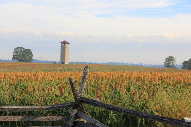
If you visit Antietam National Battlefield today, you’re likely to drive onto federally-maintained roads, climb the 60-foot Observation Tower, and survey the tranquil agricultural landscape at the foothills of the Appalachian mountains. You may be surprised to learn that visitors to Antietam have been following this same pattern for over a century. The transition from the battlefield as a place of carnage to a place of reflection began in the late 19th century. Thanks to the dedication of a handful of veterans who worked to establish Antietam as a national battlefield in the 1890s, this western Maryland landscape remains one of the best-preserved Civil War battlefields in the country. August 30 marks the 125th anniversary of the creation of Antietam National Battlefield.
Although Antietam was not among the first four national military parks created in the earliest battlefield park system (Chickamauga/Chattanooga in 1890, Shiloh in 1894, Gettysburg in 1895, and Vicksburg in 1899), Congress appropriated $15,000 “for the purpose of surveying, locating and preserving the lines of battle” at Antietam in 1890. The battlefield would operate under the auspices of the U.S. War Department. Tourists had begun to visit Civil War battlefields in large numbers as early as the 1870s. As time passed, injuries healed, and sectional tensions cooled, memory of the Civil War became a popular interest and a lucrative industry.
In the 1880s, many veterans published their memoirs as books and in periodicals and thousands of communities dedicated monuments and memorials. Reunions of former foes took place throughout the country, especially on the 25th anniversary of battles when most veterans were relatively healthy and able to travel. In an effort to reconcile the North and South back into one unified nation, late 19th century recollections of the Civil War often focused on themes of patriotism, sacrifice and valor—shared by both the Union and the Confederacy—rather than the cause of the war or the role of African Americans.
It was during this national moment of commemoration that Congress appointed a small group of Union and Confederate veterans to serve on the Antietam Board, studying the events of September 1862 and plotting where the conflict took place on the landscape. The purpose of the new battlefield park was two-fold: to serve as a memorial to the 23,000 men killed, wounded or missing at Antietam, and to teach military strategy.
Former Confederate Major General Henry Heth, along with Union veterans John C. Stearns and George B. Davis, contacted veterans to gather their recollections of the battle of Antietam. Ezra Carman, who had served as a colonel with the 13th New Jersey Volunteers, was appointed “historical expert” in 1894 and played a major role in preserving memories of the battle. Jedediah Hotchkiss, who had made maps for “Stonewall” Jackson during the war, was brought into the project to draft a comprehensive battle map but was then let go as he could not complete it in the desired timeframe.
Using information gathered through correspondence with veterans, the board created a series of 14 maps, installed tablets describing the battle, and erected roads and fences. In 1896, the War Department funded the prominent Observation Tower still in use today. The “Antietam Plan” of preservation called for Sharpsburg area residents to continue using and farming the land on which the battle raged—but for visitors to view it all from this high vista.
Stewardship of the battlefield transferred to the National Park Service in 1933, continuing the tradition of Antietam as a reflective and informative place. The work of the Antietam Board 125 years ago laid the foundation for the beloved, well-preserved battlefield park we know today. Celebrate the park’s 125th anniversary with special programs on August 29 and 30. Festivities will include ranger-led hikes, children’s activities, and a presentation by Dr. Tom Clemens on Ezra Carman. Call the visitor center at 301-432-5124 for more information.
Photos
The 1896 Observation Tower as it appeared on the 150th anniversary of the battle in 2012, NPS photo; one of the preliminary battlefield maps prepared by Jedediah Hotchkiss in 1895, from the Library of Congress Geography and Map Division; the Antietam Board published their findings as the Atlas of the battlefield of Antietam in 1904, image from Library of Congress Geography and Map Division; a 1903 stereograph by William Herman Rau shows President Theodore Roosevelt speaking at the dedication of the New Jersey monument on the 41st anniversary of the battle, from the Library of Congress.
Sources
“Antietam Battlefield – Observation Tower.” National Park Service.
Baracz, Brian. “The Early History of the Battlefield.” Antietam Journal. May 19, 2013.
Blight, David. Race and Reunion: The Civil War in American Memory. Cambridge, MA: Harvard University Press, 2001.
Lee, Ronald F. The Origin and Evolution of the National Military Park Idea. Washington, DC: National Park Service, 1973.

Contributing Author: Auni Gelles
Submit Your Events - Digital Events Welcome!
Use this form to submit an event to the online calendar
Support the Heritage Area